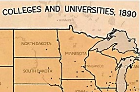
Here’s some fun for history and map buffs:
American Panorama: An atlas of United States history, is an ongoing project at the University of Richmond that currently offers maps of
- The forced migration of enslaved people, 1810-1860
- The overland trails, 1840-1860
- Foreign-born population, 1850-2010, and
- Canals, 1820-1860
It also links to a digital edition of the 1932 Atlas of the Historical Geography of the United States, but some of it has been enhanced, e.g., “animated to show change over time or made clickable to view the underlying data.” This resource provides nearly 700 maps to enjoy! Use the table of contents to browse the 14 chapters in the atlas and make selections of maps.
 For example, choose “Colleges, Universities, and Churches, 1775-1890” and then “Colleges and Universities” in 1775, then click on “Animate” in the lower left corner to watch the change in the number and geographical distribution of schools over time. But wait! Where’s UW-Whitewater on the 1890 map?? Click “text” in the upper right corner to read information about what institutions were excluded.
Want more? Andersen Library has lots of historical atlases, some with special subject emphases! Search Books, media and more (UW-Whitewater) to find gems like
- National Geographic historical atlas of the United States (3rd-floor OVERSIZE, G1201.S1 F5 2004),
- Atlas for the American Civil War (3rd-Floor OVERSIZE, G1201 .S5 A8 1986),
- The Routledge historical atlas of women in America (2nd-floor Ref Coll, HQ1410 .P68 2000),
- Disease and medical care in the United States: A medical atlas of the twentieth century (3rd-floor OVERSIZE, RA804 .S54 1993),
- Historical atlas of the North American railroad (3rd-floor OVERSIZE, HE2751 .H39 2010), and
- New historical atlas of religion in America (3rd-floor OVERSIZE, G1201.E4 N4 2001).
Please ask a librarian (visit the Reference Desk, call 262.472.1032, or choose to email or chat) for assistance with finding additional materials.
