Tag: trail
Starved Rock State Park – Oglesby, IL
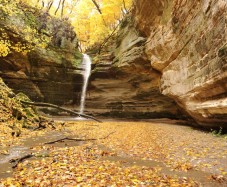
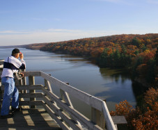
From Whitewater this is about a 2 hour drive, but it is definitely worth the drive! The main thing people go to see is in the picture on the bottom, which is actually the view from the top of Starved Rock but they also go to see the waterfalls like the top. There are about 18 waterfalls in the entire park.
Quincy Bluff And Wetlands – Adams County, Wisconsin
Quincy Bluff and Wetlands State Natural Area, Adams, WI 53910
This one is a little bit further of a drive about 2 hours away from Whitewater. But it can be some of the best hiking and has some spectacular views to witness when you get to the top. Quincy Bluff rises 200 feet above all the surrounding land and extends for 2 miles, which is similar to Gibraltar Rock my last post!
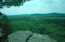
Being a bluff instead of a rock Quincy Bluff is a little more flat and easier to access. In total there are about 6,600 acres of land in Quincy Bluff and Wetlands State Natural Area. And some people claim that this land is haunted by ghosts. It’s getting warmer here in Wisconsin so if you have the chance to get up to Adams, WI to see this bluff, definitely take the trip!
Gibraltar Rock State Natural Area – Lodi, WI
Gibraltar Rock State Natural Area, Gibraltar Rock Rd, Lodi, WI 53555.
Only about an hour and 15 minutes away from Whitewater, Gibraltar Rock State Natural Area is a beautiful place to hike. The actual Gibraltar Rock which named the State Natural Area rises 200 feet above the surrounding landscape, giving you access to an amazing view.

This picture really doesn’t do the area justice. It is a tough hike so I would not recommend bringing the whole family if you have young kids. But it is something that teens and adults could definitely handle. Not too tough and some of the most beautiful views you will be able to see in Wisconsin.
Stute Springs & Homestead Nature Trail – Eagle, WI
Co Rd Z, Eagle, WI 53119
Only 19 minutes outside of Whitewater, this is an extremely beautiful place to hike. Originally this was a farm lane, but since it has been converted into a one mile loop hiking trail through the former 180 acre Stute Farm.
There is a brochure that you can access here to guide you through the trail. It shows you where the location of the outhouse, the big hill overlook, the smokehouse, the farmhouse, the milk house and many more. This is a very interactive trail that is different from anything else that I have previously posted about. This is definitely worth the trip!
Natureland Park – Whitewater, WI
Address: W8338 Territorial Rd, Whitewater, WI 53190. Natureland Park is located in Richmond Township. Natureland Park is made up of 122 acres and four hiking trails. The four trails let you get the best views of the Kettle Moraine terrain!
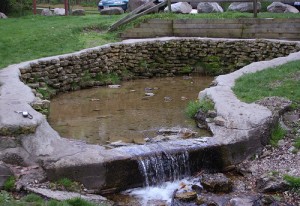
This is a fountain located in the park, this along with other amazing views are easily accessible for the whole family. There is also a picnic area and public restrooms in the park.
Bald Bluff Nature Trail – Palmyra, WI
Bald Bluff Nature Trail is only 13 minutes outside of Whitewater, located in Palmyra, WI. The history of this trail is vast, it is part of the Kettle Moraine Forest Preserve and has some incredible views. The trails are well kept and open year round. Definitely worth the drive.
Pioneers named this hill Bald Bluff because it lacked trees and was covered by prairie grasses and flowers. Though the bluff has grown over in recent years, a small portion of prairie has been preserved as a State Natural Area. It is burned periodically to keep brush and trees from shading out prairie plants. You will see this prairie at the top of the bluff.
John Muir Trail System – Whitewater, WI
The John Muir Trails, N9097 Co Rd H, Whitewater, WI 53190. Only 14 minutes outside of the UW-Whitewater campus is the John Muir Trail System. Which is actually made up of seven trails.
- Brown Loop, easy, 1.25 miles: Mostly flat trail with some small rolling hills; two moderate uphill climbs, one fast downhill and a little rocky ending.
- White Loop, moderate, 4.25 miles: Moderate hills, some rocky trail sections; one long downhill, one fast steep downhill and one moderate uphill before reconnecting with the brown loop.
- Rainy Dew Bypass (purple), hard, 4.7 miles: Moderate trail with a hard rocky up and down hill before reconnecting with the Blue/Green Loops.
- Orange Loop, moderate/hard, 5.0 miles: The first half of the trail is the white loop. Includes moderate trail with a hard, long up-hill before reconnecting with the brown loop.
- Green Loop, hard/more difficult, 7.0 miles: Moderate trail with very rocky and sandy trail sections; many hard ups and downs, with many fast sections.
- Blue Loop, hard/most difficult, 12.0 miles: Hard trail with very rocky section, many hard up hills and several fast down hills.
- Skills Course: a very short course to practice trail skills

As you can see these trails range from easy to difficult, so there are trails that everyone can enjoy. These trails are available year round and beautiful anytime of the year. More information on the John Muir Trails.
Devil’s Lake – Baraboo, WI
Located about an hour and a half from Whitewater, WI. Devil’s Lake State Park is a very popular hiking place in Wisconsin. The address for Devil’s Lake State Park is S5975 Park Rd, Baraboo, WI. Devil’s Lake has some of the most amazing views in Wisconsin. Devil’s Lake State Park is apart of the Ice Age Trails and has over 29 miles of scenic hiking available to the public.
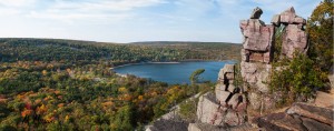
According to devilslakewisconsin.com “Trails vary in difficulty from easy to quite challenging. Not all trails are surfaced. Steep climbs or descents and stairways may be encountered. Use caution when on the steep bluffs or near cliffs. Stay well away from cliffs and watch small children closely. There is a 1-mile interpretive nature trail and 1.5 miles of trail that are accessible for people with disabilities.” They also mention that the trails at Devil’s lake are not groomed for winter hiking so this park should be on your list for summer/spring hiking.
Lake Geneva – Lake Geneva, WI
About a 35 minute drive from Whitewater, sits a town called Lake Geneva. Lake Geneva is beautiful, the scenery throughout the whole town is amazing. The town is called Lake Geneva and named for the lake that lies in the middle of it.
Lake Geneva is a huge lake, 21 miles to be exact. And so to hike completely around it, it would take about 7 hours at an average walking pace. Now don’t get me wrong walking 21 miles is awesome and all but thats an all day event and some of us just don’t have that kind of time. If you don’t have that kind of time, or simply don’t want to walk 21 miles, one suggestion I would recommend is having a ride pick you up at one of the beaches on the way around. This hike is definitely worth the time it takes and you get to witness some beautiful views as the path winds around the lake.
Outer Wear: Shorts, Long Sleeve tee, Running Shoes
Music: No Better – Allday

